|
Cordillera Administrative Region
|
Cordillera
Administrative Region |
|
|
|
Regional center |
Baguio City |
|
Population |
1,365,220 |
|
– Density |
75 per km² |
|
Area |
18,294 km² |
|
Divisions |
|
– Provinces |
6 |
|
– Cities |
1 |
|
– Municipalities |
76 |
|
– Barangays |
1176 |
|
– Cong. districts |
7 |
|
Languages |
Ilokano,
Kalinga,
Kankanaey,
Ifugao,
Itneg, Isneg, Pangasinense,
others |
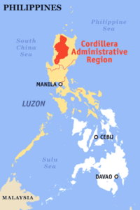
The Cordillera Administrative Region (CAR) of the Philippines
is a land-locked
region consists of the provinces
of Abra,
Benguet, Ifugao, Kalinga, Mountain
Province and Apayao.
Baguio City
is the regional center. The Cordillera region encompasses most of the areas
within the Cordillera Central mountain range of Luzon,
the largest range in the country. This region is home to numerous indigenous
tribes collectively called the Igorot.
The Cordillera Administrative Region is the only landlocked region in the
country.
Economy
Cordillera has abundant mineral reserves. These include metallic ores such
as gold, copper, silver, zinc, and non-metallic minerals like sand, gravel and
sulfur. Mineral reserves are found in all the provinces. However, mining is
concentrated in Benguet.
Geography
Political Divisions
CAR is subdivided into 6 provinces
and Baguio
City.
|
Province/City |
Capital |
Population
(2000) |
Area
(km²) |
Pop. density
(per km²) |
|

|
Abra |
Bangued |
209,491 |
3,975.6 |
52.7 |
|

|
Apayao |
Kabugao |
97,129 |
3,927.9 |
24.7 |
|

|
Benguet |
La Trinidad |
330,129 |
2,599.4 |
127.0 |
|

|
Ifugao |
Lagawe |
161,623 |
2,517.8 |
64.2 |
|

|
Kalinga |
Tabuk |
174,023 |
3,119.7 |
55.8 |
|

|
Mountain
Province |
Bontoc |
140,439 |
2,097.3 |
67.0 |
|
|
|
|
|
|
|
|

|
Baguio City |
— |
252,386 |
57.5 |
4,839.3 |
¹Baguio City
is a highly urbanized city; figures are excluded from Benguet Province.
Physical
Almost the whole region is situated in the mountainous Cordillera
Central range. Located there is Mount Pulag,
the second highest mountain in the country, rising at 2,922 meters. Various
rivers start here, like the Cagayan River and the Agno River.
Tourist attractions
Tourist attractions in the region include the world famous Banaue
Rice Terraces in the province
of Ifugao.
This is supposedly considered as the "Eighth Wonder of the World".
Natural attractions of the region include the Sumaguing
Cave in Sagada and the mummy caves of
Benguet and Mt.
Province. There are four National Parks: Cassamata Hill, Mount Pulag
(the second highest mountain in the Philippines
with an elevation of 2,922 meters above sea level), Mt.
Data and Balbalasang-Balbalan,
located in the province
of Kalinga. Kalinga is
also offering world class white water rafting along the chico river.
History
On July 15,
1987, Executive
Order No. 220 was issued creating the Cordillera Administrative Region. It is
composed of provinces which used to be part of the Old Mountain
Province. Republic Act No. 6766 was passed on October 23, 1989. It provided
for an Organic Act for the Cordillera Autonomous Region. It mandates the
creation of an autonomous government to be headed by a Regional Governor. It
creates a Regional Assembly that will enact laws of regional application and a
regional judiciary composed of a supreme court and lower courts. The act also
directs the proposed autonomous government in the Cordillera to exercise governmental
functions, including the raising of taxes, but excluding defense, foreign
affairs and monetary functions. However, the Constitution requires that the act
has to be ratified by the people in a plebiscite. It was originally scheduled
on December 27
of the same year but was reset to January 30 the
following by virtue of the Commission on Elections. During the said plebiscite,
it was only Ifugao which voted favorably.
Republic Act No. 8438 dated December 22, 1997 created the
Cordillera Autonomous Region. In January 1998, a group of lawyers challenged the constitutionality of
the act. A plebiscite held on March 9 of the same year was held and invalidated
the act. The region was created but reduced to a regular administrative region.
|